Cloud-native-geo-tutorial
A self-directed tutorial on cloud-native geospatial technologies including formats, platforms, geoAI agents, and more.
Cloud-Native Geospatial (CNG) is a self-directed geo tutorial I've built following the inaugurtal Cloud Native Geospatial conference to systematically master our modern geospatial stack including cloud-optimized data formats (COG, GeoParquet, Zarr, PMTiles), scalable cloud infrastructure, spatial data warehousing, and geospatial AI. You can explore the full tutorial at cloud-native-geo-tutorial.thomashervey.net/cng-modules.
The (currently) 33-module sequence moves from foundational formats through STAC catalogs, H3 indexing, vector tile serving, and datacubes, before advancing into AI/ML including geo-foundational models, retrieval-augmented generation over geospatial data, NL-to-SQL pipelines, and multi-step agentic query systems.
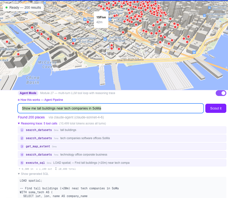
The "Scout" tool (pictured above) is an agentic geospatial query app that answers natural language questions about spatial data and renders results on an interactive map. Scout implements a multi-turn LLM tool loop backed by Claude, with a reasoning trace UI, vector search over a GeoParquet dataset, schema-aware RAG, and live execute_sql calls against DuckDB-WASM in the browser. It's a working prototype of the kind of spatial AI reasoning that many geospatial companies are actively building toward. Reach out if you want to try it with a demo link.
Recent modules have focus on agentic GIS prototyping (CARTO-style), NL-to-SQL web GIS (Felt-style), EO feature extraction (Element84-style), and further tinkerings with open problems at the geospatial AI frontier.
Map That? is a companion Chrome Extension that acts as an intelligent spatial scout for the modern web. As you browse, it automatically parses sites to find hidden geospatial resources (ArcGIS Map Servers, GeoJSON, Shapefiles, and KMLs) and instantly prompts you to preview and visualize them in modern web-GIS tools like Felt. It bridges the gap between unstructured web content and professional GIS visualization, perfectly complementing the agentic reasoning workflows explored in the CNG geo tutorial.
Spatial Eval (How Well Do LLMs Know Where Things Are?) compares LLM bounding box predictions against authoritative neighborhood boundaries. This tool evaluates the "spatial coordination" of foundational models using geometric precision metrics (L1). Users can toggle different ground truth sources—containing points, bounding boxes, and polygons—and contrast them against multi-model LLM responses across different prompt variants. The app includes IoU heatmap leaderboards, source configuration controls, and experimentation tabs to test how well models can reason about geographic reality. While currently focused on geometry identification (L1), it serves as a foundation for testing higher levels of geospatial understanding like topology (L2), symbolic rules (L3), and causal prediction (L4-L5).
Gallery